Maine

We go to Maine on Friday, via United Airlines to Bangor and then north from Bangor by car, past Mount Katahdin and Baxter State Park, further into the north woods to Piscataquis County, about as far north as counties in the continental States dare go. I’ve never been to Maine, and we’ll be so far north that to our left, to our right, and straight ahead all the land will belong to Canada. It’ll be just like the Charge of the Light Brigade, though hopefully without the cannon.

Did you know that there’s more Allen’s Coffee Brandy sold in Maine than anyplace else? Did you know that there’s something called Allen’s Coffee Brandy? Until sometime in the early 2000s it was the most popular liquor sold in Maine, though now various vodkas are higher on the list. It’s still well up there. There’s also a popular regional soft drink called Moxie, and in Maine the mix of Moxie and Allen’s Coffee Brandy is called a “Burnt Trailer.” The mix of Allen’s Coffee Brandy and Diet Moxie is called a “Welfare Mom.” Even in the interest of science, I doubt that I’ll try either one.

Moxie, by the way, was originally sold as a tonic brewed to prevent softening of the brain, nervousness, and insomnia. I might could use some of that. Moxie and vodka, by the way, is a Moxie mule.

Maine has a population of 1,372,000, 92% Anglo, with a total area of 35,385 square miles. That puts it 38th on the list of states by population density, ahead of Oregon, Utah, and Kansas. Roughly 80% of Maine is forested, and most of it’s population is in the remaining 20%. It’s the largest New England state. With a few exceptions, Mainers cluster reasonably close to its coast, but even along the coast there aren’t large urban centers. Maine’s largest city, Portland, has a population of 68,424. Lewiston, the second city, has 38,493. In the north and west of the state there’s forest, and some mountains, too. The north end of the Appalachian Trail is Mount Katahdin, 5,269 feet. Then there’s some more forest.

About half of the population lives in the southeast corner around Portland. All of the reported vampire population is in Jerusalem’s Lot, and hopefully they’ll stay there.

William Bradford, The Schooner Jane of Bath, Maine, 1857, oil on canvas, Art Institute of Chicago.

Reading Maine history is peculiar. Until the Civil War, Maine seems to have been the hottest thing going. They built ships in Maine. Maine’s captains sailed the world. Maine produced timber, and there was land to be had. That’s not to say that Maine didn’t have its troubles: the English were prone to try to move the border, and Mainers had to rid themselves of Massachusetts. There were always French folk trying to migrate south from Canada. Into the 20th Century though if you bought a shoe it was like as not made in Maine. If you bought a sailing ship it was like as not made in Maine.

Then winter came, and it wasn’t. L.L. Bean boots and Hinckley Yachts are still made in Maine, and there must still be a Bath Iron Works, but I think Maine’s most significant exports now are Steven King novels and potatoes. Even Allen’s Coffee Brandy and Moxie are made in Massachusetts.

Jacobson, Antonio N., S.S. State of Maine, ca. 1892, oil on canvas, Maine Historical Society. The S.S. State of Maine was built in Bath, Maine.

Before the Civil War Henry David Thoreau wrote three travel essays about Maine, two of which were published in periodicals during his life and collected after his death as The Maine Woods. His trips weren’t far from where we’re going. On one trip he climbed Mount Katahdin. On another a Native American guide took him and a companion by canoe to Moosehead Lake. Some of the essays are pure travelogue, but they’re well written and appealing, with enough wilderness spark to provide drama. Some of the writing is better than mere travelogue. From time to time in The Maine Woods you’ll find some of Thoreau’s loveliest observations about nature, and nobody ever did mysticism and nature better than Thoreau.

Is it the lumberman, then, who is the friend and lover of the pine, stands nearest to it, and understands its nature best? Is the tanner who has barked it, or he who has boxed it for turpentine, whom posterity will fable was changed into a pine at last? No! No! It is the poet . . . . ((Thoreau, Henry David, “Chesuncook”, The Maine Woods at 112, Yale University Press 2009, New Haven, Ct.))

You’ll also find his god-awful attempts to reproduce the dialogue of his Native American guide. Tonto’s script writers produced less stilted vernacular. “Kademy . . . good thing–I suppose they usum Fifth Reader there . . . You been college?”((Thoreau, Henry David, “The Allegash and the East Branch”, The Maine Woods at 183, Yale University Press 2009, New Haven, Ct. Interestingly, “that looks like Ned and the First Reader” was my father’s standard description of messy work, as in “your casting looks like Ned and the First Reader.” I never knew there was more than one Reader until I read Thoreau. I still don’t know who Ned was.)) After reading Thoreau’s dialogues, you realize why his best work is about living alone at Walden Pond.

Paul Bunyan statue, Bangor, Maine. Paul Bunyan was also resident in Michigan, Minnesota, and Nova Scotia.

In The Maine Woods, Thoreau mentions the red shirts of the lumbermen several times. I thought certain that when we got the gear list for Libby Camp it would require us to bring red flannel shirts, but there was nary a one listed. These days anglers are more prone to camouflage than red, on the theory that fish will more easily spot threats who wear bright colors. Whatever the styles preferred by 19th century Maine lumbermen or 21st century fly fishers, it’s hard now to find a red flannel shirt, even with the help of the internet. The closest I could come was an L.L. Bean chamois shirt, probably made in China, and somehow the notion of buying a heavy shirt during the current Houston heat wave was just more than I could stomach. I’ll wear no red in Maine, and I apologize to Henry David and Paul Bunyan.

We could go to Maine to fish the seacoast. It’s a drowned seacoast, a seacoast that because of rising oceans after glacial retreat left a rugged and interesting shore. This time of year there should be not only striped bass but migrations of bluefish and false albacore. I do get seasick though.

Cornelia “Fly Rod” Cosby, the first registered Maine guide.

There was also a time when you could go to Maine to fish for Atlantic salmon, but through a combination of dams, pollution, and over-fishing we’ve done an excellent job of eradicating U.S. Atlantic salmon runs. Maine is the last North American place south of Canada where there are Atlantic salmon, but they’re critically endangered.

There are largish native wild brook trout left in Maine, when they’ve otherwise disappeared from the rest of their U.S. native range. Generally they can’t compete with rainbow trout introduced from the Pacific Northwest and brown trout from Europe, so outside of Maine they’ve been marginalized into smaller streams, and there’s not sufficient food in the streams to grow big fish. But in Maine for whatever reason they’re still the inland fish of choice.

Along with the brook trout there are also landlocked salmon. Landlocked salmon are Atlantic salmon that at the end of the last glaciation were cut off from the ocean. Apparently they make their spawning runs from lake to river in September, and they’re absolutely right to do so. September is always the best time to travel, when temperatures are starting to cool and the kids are back in school.

The last of the large native brook trout in the U.S. are a good enough excuse to see the Maine woods, but there’s also a sporting tradition. Train travel opened the Maine woods to both Henry David Thoreau and lots of traveling fishers and hunters. By the end of the 19th century, Maine fishing and hunting camps were scattered through the far Maine woods, and they were the very thing. We’re going to Libby Camp, which can trace it’s ancestry to the 1880s, but there are plenty of others. There are few things as iconic to a fly fisher as a Maine camp.

We know there can’t be a fish because the angler is wearing a red shirt. He must have dropped his hat.

In other matters, Mainer’s didn’t vote for Donald Trump in either 2016 or 2020, voting 48.2%, or 357,735, for Clinton, and then 51%, or 435,072, for Biden. Interestingly–and this is repeated in other states as well–there is more than a 3% drop in votes for the Libertarian candidate between 2016 and 2020, from 5.09% for Gary Johnson in 2016 to 1.73% for Jo Jorgensen. One supposes two things, that about 2% of the population really does vote Libertarian, and that in Maine in 2016 about 20,000 voters wouldn’t vote for either Hillary Clinton or Donald Trump. In 2020 most of those 20,000 voters were either more enthusiastic about Biden or less enthusiastic about Trump.

There was 73% eligible voter turnout in Maine in 2016, then 78% turnout in 2020. That’s huge turnout. To put that in perspective, turnout nationally in 2020 was 66.7%.

Maine 2020 presidential election results by county, Wikipedia. That would also double for a pretty good population map.

Maine does something peculiar with its electoral college votes in presidential elections that I don’t think is done anywhere else. Instead of all or none, it splits two of its four electoral college votes by congressional district, so in 2020 Trump took one electoral vote and Biden three others. That was the only electoral vote for Trump from New England. It’s not a bad way for the electoral college to work, though unless other states did the same thing it only hurts Maine’s overall majority.

Neither of Maine’s Congressfolk are Republican, though one of its senators is a moderate Republican, which along with Atlantic salmon is a critically endangered species. Unlike the rest of Mainers, she doesn’t have a reputation for being particularly independent. The other senator, Angus King, is in fact independent, but caucuses with the Democrats.

Both Maine’s state senate and house are mildly Democratic. Its governor is Democratic.

One last note on fly fishing in Maine. Mainers created some of the most beautiful streamer flies in the American catalogue. They’re simpler variations of classic British salmon flies. I tried to tie some, though it was hard, and my results were decidedly mixed. I’m sure they’ll look a lot better in the water, and just fishing them is enough of a reason to go to Maine, whether or not I have a red shirt.
Indiana

It’s August. Houston is ending its second month of record heat with no rain. This morning when I walked the dogs at 6:30 it was 80°, and the high today is projected to be 101°. That’s cooler than yesterday. After the freezes of the last two years the joke is that post-global warming there are two seasons in Houston, Hell and when Hell freezes over.

This morning in Indiana it was 57°. There’s no rain there, either, but the high in Indiana today will only be 91°. That’s a perfectly reasonable August day. We’re going to Indiana to enjoy beautiful summer weather.

Yesterday at a dinner I sat across from a psychoanalyst who grew up in Indiana. She left in 1974, which she said was the height of Indiana’s Rust Belt economic failure. Indiana, Ohio, Michigan, Pennsylvania, upstate New York, West Virginia . . . That must be the year we started buying Japanese cars, outsourcing carburetors to Mexico, and importing computer chips from China. Ok, maybe the computer chips came later. Indiana’s economy was either manufacturing or farming, and since its peak in the 1950s, American manufacturing in the Rust Belt had declined into collapse. She said that still, it was a wonderful place to grow up, and that where we were going, near Crawfordsville, is lovely. She also said she couldn’t have done what she does in Indiana. I suppose that in the Rust Belt years there wasn’t money for fripperies like mental health.

U.S. Expansion 1790, Perry Castaneda Map Collection, University of Texas.

I think we erred when we stopped calling Ohio and Indiana the Old Northwest. Now it’s the Midwest, lumped together with Kansas and Nebraska, but historically the Old Northwest was the heart of the first westward expansion of the brand new United States, and it’s where we abandoned any pretense of Native American assimilation. That bit of our history deserves pondering, but until now I never have. Indiana Indians refused to transform into European farmers, and even if they’d tried we probably wouldn’t have let them. We certainly didn’t put up with that sort of nonsense with the South’s civilized tribes.

By 1816, when Indiana became the 19th state, there was no remaining Native American opposition to European settlement. Indiana had gone from the 1810 formation of the Tecumsah Federation to unopposed European settlement in six years. Death and removal had become the tools of American expansion, and would remain so.

Kurz & Allison, Battle of Tippecanoe, 1889, Library of Congress, https://loc.gov/pictures/resource/pga.01891/.

William Henry Harrison, the future short-lived President, was appointed Indiana territorial governor in 1801. He was a well-to-do Virginia boy–he was still in his early 20s–and he had two goals; to open the territory for expansion, which he did, and to claim the territory for slavery, which he didn’t.

He failed to expand slavery for the most unexpected of reasons: white Southern settlers. When Indiana’s first constitution was written, the majority of Indiana settlers were Southerners from slave states, Kentucky, Virginia, North Carolina, but they were poor Southerners from slave states, not William Henry Harrison’s slave-owning aristocracy. When they adopted their new statehood constitution, they prohibited slavery. It may have been the right thing to do, but their motive wasn’t humanitarian. They didn’t want to compete with Southern slave owners for land.

They didn’t want to compete with African Americans either. Indiana’s 1851 constitution prohibited black immigrants, and imposed registration requirements for existing black inhabitants.

The Lincoln family was part of the migration of poor Southerners from Kentucky to Indiana, until they finally moved on to Illinois when Abraham was 21. Indiana missed a bet when it let young Honest Abe leave.

St. Mémin, Charles Balthazaqr Julien Fevret de, 1800, William Henry Harrison, 9th President of the United States, engraving, Library of Congress; Tecumseh, between 1860 and 1900, wood engraving, Library of Congress.

Notwithstanding Lincoln, Indiana has a reputation for conservative politics, and its current politics certainly are. It’s the state that gave us Mike Pence, former vice president and before that the Indiana governor. Poor Pence. He is so hated as a sycophantic toady on the left and as a craven coward on the right that he doesn’t get the credit he deserves for stepping up on January 6. Me? I will always be thankful for Pence, though I wouldn’t vote for him. I suspect that history will be kinder to Mike Pence than we are, at least if the nation survives the next score years.

In 2016, Donald Trump carried Indiana by 56.9% to 37.8% for Hillary Clinton, with 2,734,958 total votes. The Libertarian, Gary Johnson, received 5% of the vote. Four years later Trump carried 57.02% of the vote and Biden 40.96%, with 3,033,118 total votes. The Libertarian, Jo Jorgenson, dropped to 1.95%. It probably should be noted that Trump’s numbers might have been inflated by having native-son Pence as a running mate, but I suspect that in Indiana Trump would have walked away with the elections anyway. Democrats won in areas you’d expect, urban Indianapolis and the college town of Bloomington. Then there are the somewhat unexpected old industrial counties, Lake and St. Joseph in the far northwest, but unexpected to me because I know very little of Indiana. Finally there’s Tippecanoe County, with a population of 186,251. It voted for Trump in 2016, but switched to Biden in 2020. It is the home of Purdue University, and maybe that explains it, though switched majorities are always interesting.

Indiana 2020 election results by county, Wikipedia.

Barrack Obama did squeak by with a win in Indiana in 2008, 50% to 48.9%, but he didn’t repeat in 2012 when he dropped a full 6%. All of the statewide officials in Indiana are Republican, as are both senators and seven of the nine members of Congress. In the state assembly, 40 of the 50 senators and 70 of the 100 representatives are Republican. I reckon Indiana deserves its conservative reputation.

Geographically, in the north Indiana is bordered by Lake Michigan and Michigan, in the east by Ohio, in the south by Kentucky, and in the west by Illinois. The Ohio River separates Indiana and Kentucky, and the Wabash River flows along the lower third of the Illinois-Indiana border–the part where the border is squiggly. It is the 38th state by size, between Virginia and Maine, with 35,870 square miles, but it’s 17th by population with 6,833,037 people as of 2022. Massachusetts is 16th.

Northern and central Indiana were glaciated and tend to be flat to rolling. There’s corn in them there rolls. Corn and soybeans make up about 60% of Indiana’s agriculture production. Unglaciated southern Indiana is apparently more varied, with sedimentary deposits of limestone, shale, sandstone, and dolomite, some of which apparently protrude as bluffs and whatnot. Coal mining in the south is located north across the Ohio River from Kentucky’s northwestern coal region. “Paradise” is on the Green River in Kentucky, not the Wabash, and “Coal Miner’s Daughter” set in Indiana just ain’t quite the thing.

Current Indiana coal permits. The blue circles are surface mines, the purple squares are underground, and the yellow stars are processing facilities. I think. Indiana Department of Natural Resources.

With all that sedimentary rock in south Indiana filtering water, farms growing corn, and proximity to Kentucky, Indiana ought to be an excellent location for bourbon, and apparently there’s excellent bourbon made in southern Indiana. In the interest of science I’ll go out of my way to try some.

In addition to corn and good water, Indiana has a ready supply of white people. Indiana is 77% Anglo, with less than 10% of the population African American, less than 8% Hispanic, and 3% Asian. Indianapolis, the state’s largest city with about 900,000 people, is 88% Anglo. Only in the northwestern industrial corner closest to Chicago are there sizable African American or Hispanic populations, in Lake County 18.9% and 17.7%, respectively.

There are two reasons to go to Indiana to fish. This gets complicated, but in the Newer Northwest, Oregon, Washington, and Northern California, they haven’t quite managed to kill off all their steelhead, and there is still a steelhead fishery there, some of it wild. When we fished in Washington and Oregon, we fished for steelhead, though we only caught a total of one. Steelhead are rainbow trout that join the navy and go to sea, then return to their natal rivers to spawn. Genetically they are exactly like the rainbow trout that never leave the western rivers. Behaviorally they are much closer to Pacific salmon. Feeding in the Pacific they grow large enough to rival some of the Pacific salmon as well.

Sage, Dean, Townsend, C.H., Smith, H.M., Harris, William C., Great Lake Trout, 1924, Salmon and Trout 351, MacMillan Company, New York, New York, Freshwater and Marine Image Bank, University of Washington. The scientific name is now Salvelinus namaycush.

Meanwhile the Great Lakes were once populated with lake trout, a close cousin of brook trout. Lake trout are the largest of the chars, and are native to the northern US and Canada. I don’t think they were ever particularly popular with fly fishers–they live deep in big waters, plus they are invasive in places like Yellowstone–but in the Great Lakes they were once a popular gamefish for gear fishers and an important commercial fishery. Then they were effectively wiped out of the Great Lakes by pollution, overfishing, and invasive sea lampreys after the Welland Canal connected the Lakes to the Atlantic. I could have bad dreams about invasive sea lampreys.

To replace the lake trout fishery, the Old Northwest settled on stocking New Northwest steelhead. Now in Ohio, Pennsylvania, Indiana, and Upstate New York–Steelhead Alley–fly fishing in the dead of winter for steelhead migrating into rivers from the Great Lakes is a thing. In my mind it’s a strange, cold thing, but still a thing. To steelhead anglers in Washington, Oregon, and Northern California, the notion that fishing for a stocked freshwater lake fish and calling it steelhead is anathema. It really is quite the etymological dispute.

We are not going to fish for Great Lakes steelhead, or whatever it is they’re called that doesn’t make somebody angry. We are going to fish for smallmouth bass, which are native to Indiana. I’m told that Indiana is the very place for smallmouth bass, mostly by the State of Indiana. I am also told, mostly by the State of Indiana, that the particular place we’re going, Sugar Creek, is among the very best places for Indiana smallmouth. I hope the State of Indiana is at least as honest as its two famously honest sons, Abe Lincoln and Mike Pence.

Missouri

On Monday we decided that on Friday we’d drive to Missouri, to Branson. That’s a short turnaround, but I’ve been to Missouri plenty. My Grandmother Eva–not that Grandmother Eva, the other Grandmother Eva–was born in Missouri, in Osgood near the Iowa border, in 1890. When I was five or six, circa 1963, we took her home from Texas to see her siblings. We stayed with one of her sisters, and while the house may have had electricity, it didn’t have indoor plumbing. There was a pump in the yard for water and an outhouse for other sundry stuff. It was on a gravel country road, and at night I saw fireflies for the first time. It was wonderful.

I’ve been to Missouri some since, enough to know that Kauffman Stadium in Kansas City is as pretty as MLB stadiums get (though I don’t recommend it in August), and that the riverfront town of Hannibal has seen better days. I’ve been to Missouri enough to know that while any Texan would tell you that Missouri barbecue is mediocre stuff, the sandwiches at Gioia’s Deli on The Hill are worth the effort. On The Hill you can still imagine Joe Garagiola and Yogi Berra as children in the neighborhood’s heyday. Not so much Mark Twain and Hannibal.

Kauffman Stadium, Kansas City, 2015.

There are good fishing rivers in the Missouri Ozarks, and if we were being intellectually honest we would target native Missouri smallmouth, but we haven’t fished for trout in a while, and there are plenty of Missouri rivers stocked at one time or another with trout. In Branson there is the Ozarks’ White River at the Taneycomo Lake dam. One Missouri spring creek near Branson, Crane Creek, claims the purest strain of McCloud River redband trout in the world. They were stocked in the 1880s from eggs imported from California and supposedly dumped off a bridge by railroaders.

Records are a bit sketchy, but Crane Creek has been stocked no more recently than the 1920s. Because it was the site of the second national fish hatchery, the McCloud River redband was the original source of most of the stocked rainbow in the world. Only in Crane Creek does the original strain remain unmixed with other rainbow subspecies.

By all reports the Crane Creek trout are small, skittish, and hard to catch. The stream is narrow and overgrown, and there’s poison ivy and water moccasins. Of course that last is likely overblown, and there are more likely a lot of non-venomous northern water snakes and maybe some moccasins. It is a herpetologist’s truism that everybody thinks that every water snake is a vicious, vindictive, or aggressive cottonmouth, but they aren’t more vicious, vindictive, and aggressive than most of us, and most of the snakes you see in the water aren’t moccasins.

Anyway, it sounds like we have to fish Crane Creek.

I’ve been looking at Missouri rivers for a while, thinking we would avoid Branson. We could do it, but Branson is convenient. It’s a strange place, a tourist destination that is a distant cousin to Nashville. It is a vacation destination for devout Southern and Midwestern protestants, seemingly devoted to clean living, family entertainment, golf, lakeside condos, and fatty foods. There is fishing though, and a good fly shop. It’s about a 10-hour drive from Houston. We can take the dogs, and coming home we can spend the night in Bentonville, Arkansas. Branson eateries tend towards family entertainment and national chains. Bentonville, as the business hub of Walmart, has better places to eat.

A short note on pronunciation

Apparently there’s no correct pronunciation of Missouri. The most common pronunciations are either Missour-ee or Missour-uh, but neither is incorrect, and they aren’t even the only ones. I grew up with Missour-uh, and long assumed that since I had some Missour-uh ancestry my pronunciation must be correct, but no. Still, it’s not wrong either. Oddly, how you say Missouri isn’t governed by education, wealth, race, or even geography. It’s not a South versus Midwest thing. It’s just the luck of the draw or maybe personal taste. Some Missourans say Missour-uh, some Missour-ee, and some go back and forth between them. All things should be so accommodating.

The Missouri Compromise

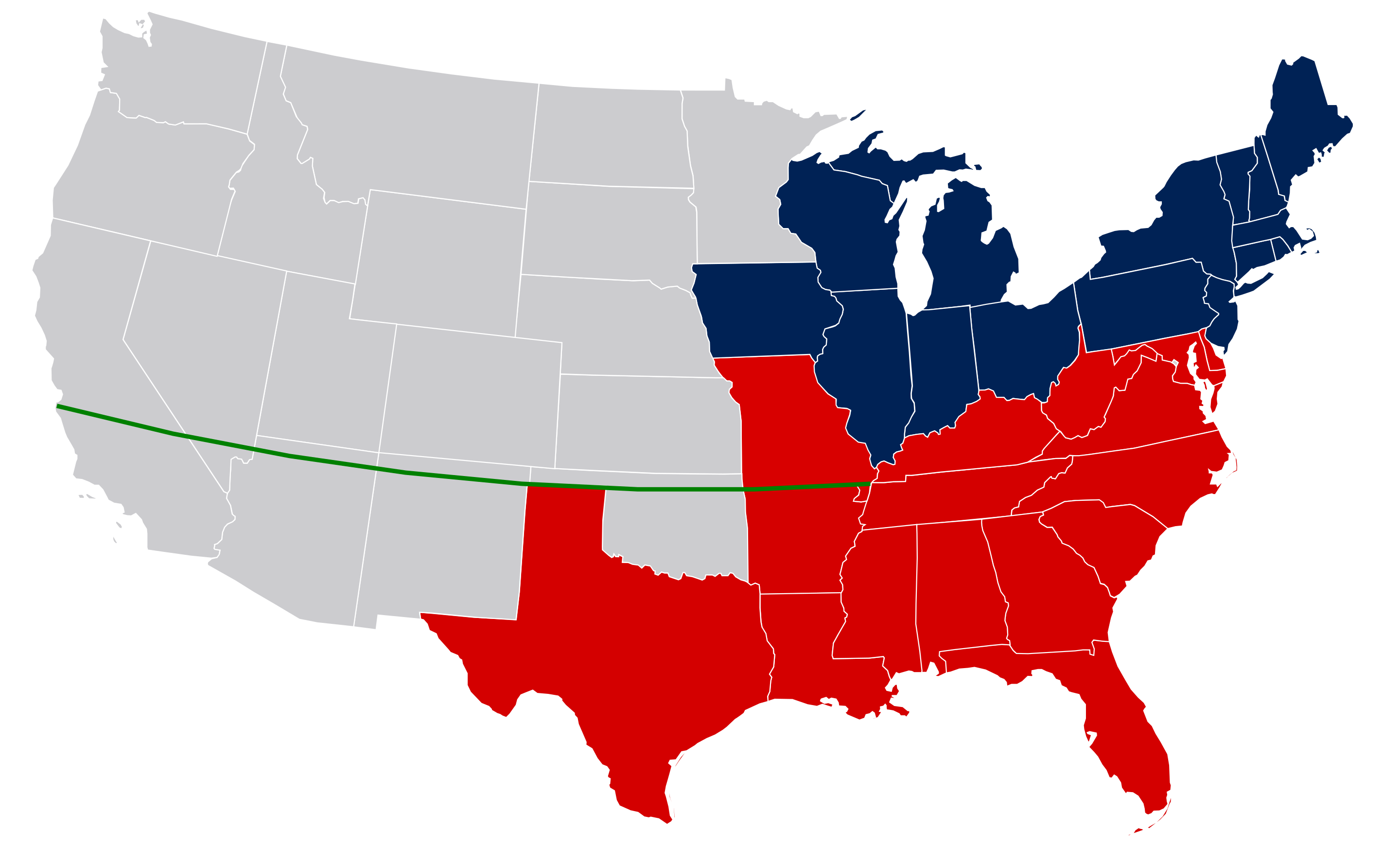
The U.S. acquired Missouri in 1803 as part of the Louisiana Purchase, and St. Louis became the jumping-off point for a big part of western expansion. In 1821 it became a state under the Missouri Compromise: to maintain political balance, Maine entered the Union as a Free State, while Missouri entered as a Slave State. After the admission of Missouri, no new territory north of the 36°30′ parallel could enter the Union as a slave state.

undefined

Julio Reis, Map of the United States c. 1849 (modern state borders), with the parallel 36°30′ north, Wikipedia, 2009.

The state lines in the map above are mostly modern boundaries. West Virginia wouldn’t exist until the Civil War. None of the grey states existed, except California. It’s the green line, the extension of the Mason-Dixon Line along 36°30′ that purportedly controlled American expansion for the next 30 years. See that far north border of Texas, and the Oklahoma Panhandle? The Oklahoma Panhandle was originally claimed by Texas, but when Texas entered the Union in 1845, that northern bit was above the line. To preserve the Missouri Compromise, it was cut off and left as part of the Indian Territory.

After the Missouri Compromise, there was a push among Southern slaveholding states to annex Cuba as a Slave State, to maintain Southern legislative power. It wasn’t going to happen. Cuba was valuable to Spain, and there was no real interest in annexation among most Cubans, but it’s amusing to guess whether Governor Fidel would have been a Republican or a Democrat.

The Missouri Compromise lasted until the Kansas-Nebraska Act of 1854 provided that Kansas and Nebraska would enter the Union as slave or free based on the votes of Kansas or Nebraska settlers. The seemingly sensible resolution threw the now-raging national slave debate into armed war. Abolitionists came to Kansas from the north, and pro-slavery Border Ruffians raided into Kansas from Missouri, and all of them brought convictions, guns, and knives. John Brown got his bones in Bloody Kansas. Kansas finally voted to enter the Union as a free state, but allowing popular local vote to determine only made the Civil War inevitable.

In 1857, in the Dred Scott decision, the Supreme Court determined that African Americans could not be citizens, that the federal government could not prohibit slavery in its territories, and for good measure that the already superseded Missouri Compromise was unconstitutional.

Reynolds's Political Map of the United States 1856.jpg

New York: Wm. C. Reynolds and J. C. Jones – “Reynolds’s Political Map of the United States” (1856) from the Library of Congress Geography and Map Division.

Population and Demographics

In 1820, the 66,586 population of Missouri was .6% of the nation’s total population. By 1920, Missouri’s 3,404,055 population was a biggly 3% of the total. St. Louis was the 6th largest city in the U.S., and had two major league baseball teams, the Cardinals and the Browns (now the Baltimore Orioles). Kansas City was 19th. By 2020, the St. Louis metropolitan statistical area, with a population of 2,820,253, was ranked 21st. Kansas City, with 2,192,035, was 31st.

In 2020, the total Missouri population of 6,154,913 was .1% of the total U.S. population of 329.5 million. It had gone from .6% in 1820, to 3% in 1920, to .1% in 1920. Missouri still had two major league baseball teams, though one was now the Kansas City Royals. The Kansas City Chiefs won the Super Bowl in 2020. They won again this year.

Missouri’s national importance was driven in part by Mississippi River trade and Westward Expansion, and with the decline of both, the its national importance also declined. Still, Missouri is where the South and the Midwest meet, in the same way that Texas is where the South and the Southwest meet. It is a black/white population, with heavy emphasis on white. Approximately 82% of Missourians are white, with less than 5% of that population Hispanic.

About 12% of the Missouri population is black, mostly centered in St. Louis and Kansas City, and in a stretch of southeastern counties along the Mississippi River, an apparent extension of the Arkansas and Mississippi Deltas. That delta population is likely a remnant of slavery, and the population growth in St. Louis and Kansas City was fueled by the Great Migration, both from the South and from less populated areas in Missouri. Hannibal, for instance was 14.5% black in 1900, but only 6.1% by 2020. Conversely, St. Louis was 6.1% black in 1900, but by 2020 the greater St Louis area was 17% black.

Satchel Paige, Untitled Photo, between 1935 and 1942, Library of Congress Prints and Photographs Division, Washington, D.C.

It’s worth noting that Kansas City became an African American cultural Mecca, being, along with New Orleans, Chicago, and New York, a major jazz hub. Count Basie was from Kansas City. So was Dexter Gordon, Lester Young, Big Joe Turner, Count Basie, and Charlie Parker. It was also the home of the Kansas City Monarchs, perhaps one of the greatest baseball conglomerations ever. Jackie Robinson jumped from the Monarchs to the Brooklyn Dodgers. Satchel Paige played for the Monarchs, and so did Cool Papa Bell, Turkey Stearns, Wilbur Rogan, and Buck O’Neil.

Lester Young by Ojon Mili. Time Inc. – Life magazine, Volume 17, Number 13 (page 40), Public Domain, https://commons.wikimedia.org/w/index.php?curid=44359804

The American Jazz Museum and the Negro Leagues Baseball Museum are at 18th and Vine in Kansas City, and are worth a special trip. And did I mention that Kauffman Stadium is one of the finest stadiums in Major League Baseball? It’s just too bad that Kansas City Barbecue isn’t better.

Of course Mark Twain is from Missouri, and T.S. Eliot, and Maya Angelou.

Politics

Both U.S. Senators from Missouri and four of the six Representatives are Republican. All of the six statewide elected officials, governor, lieutenant governor, secretary of state, auditor, treasurer, and attorney general, are Republican, and there are sizable Republican majorities in the state senate and house of representatives.

In 2020, Donald Trump carried the state by 56.80% of the vote, compared to Joe Biden’s 41.41%. Biden carried only Boone, Jackson, and St. Louis Counties. Jackson is Kansas City, St. Louis is, well, St. Louis, and Boone, in the middle of the state, is Columbia, home of the University of Missouri. Like other states, less-populated areas vote Republican, urban centers and college towns vote Democratic.

2020 presidential election, Missouri, By KyleReese64 – Own work, CC BY-SA 4.0, https://commons.wikimedia.org/w/index.php?curid=95975673

Geography

Missouri is divided into three major geographic regions, the Ozark Highlands, the Northern Plains, and the Coastal Alluvial Plain. No mysteries here. The Northern Plains are rolling, and you can grow corn and soybeans, soybeans and corn, and corn. There are lots of streams. It’s Iowa just a wee bit south of Iowa.

The smallest region, the southeast Coastal Alluvial Plain, is an extension of the Arkansas Delta, which is just like the Mississippi Delta but west of the Mississippi. It’s flat, wet, and a good place to grow rice, and cotton. Of course cotton.

The Ozarks are the Ozarks. They extend into Arkansas, Kansas, and Oklahoma. It’s a dome, cut into topography by erosion, faults, bluffs, rivers, and streams. It’s beautiful, dramatic country.

On the state’s eastern border there’s the Mississippi River. Cutting across the center of the state, roughly along the line that divides the Plains and the Ozarks, is the Missouri River. The Missouri meets the Mississippi at St. Louis.

Mark Twain’s Confederate Service

Mark Twain served as a Confederate militia lieutenant in Missouri, and he deserted after two weeks. Twain scholars have suggested that his desertion didn’t evidence opposition to the Confederacy, as much as concern as to the likely outcome of militia service in what was substantially Union-controlled territory. It’s pretty likely that Twain was dedicated to the South, and that his later reevaluation of the South and its cause was a principal source of his satirical brilliance. It’s hard to imagine Huck Finn written by someone who didn’t distrust most people’s pronouncements, including from time to time his own.

Osgood, Missouri, 2021.

A Texas Whatever in Connecticut’s Court

The best known writer from Connecticut, Hank Morgan, was a travel writer, and a good one, or at least a fun one to read. It doesn’t get edgier than when his strong Yankee character clashes with the customs and peculiarities of England. No writer is as arrogantly certain of his own superiority as Morgan, but that’s part of his virtue, and his descriptions are completely trustworthy. He has other shortcomings: I’m still not clear how Morgan got from Connecticut to England.

I’ve been to Connecticut once before, to poke around New Haven, which is best known for its pizza. I didn’t have any, not knowing then what I know now.

This time we’ll be in northwest Connecticut, on the Housatonic River. How do you say that? House-a-tonic? Whose-a-tonic? I don’t know, though even I know that it’s not Conn-ec-ti-cut, but isn’t that “c” dandy to pronounce? Who doesn’t like to? Connect. Connect. Conne-c-ti-cut.

Daniel Beard, Travel Writer Hank Morgan Up a Tree, 1889, Charles L. Webster & Co., New York, New York.

Connect-i-cuters don’t really have a very useful appellation. Nothing rolls off the tongue; not Connecticucator, Connecticutensian, Connecticutan. . . According to Webster (who was from New Haven), Connecticuter is correct, but I figure if I told somebody they were a Connecticuter, I’d have made an enemy for life.

Connecticut Yankees are also known as Nutmeggers, presumably because of the state’s vast fields of native nutmeg.

Demographics and Geography

Connecticut is the third smallest state, with 4,845 square miles. It’s smaller than Hawaii (with 6,423 square miles), but more than four times larger than Rhode Island (1,034 square miles). For all of that paucity of space, it is heavily populated, with 745 people per square mile. Compare that to Wyoming, with 55 people per square mile. In order of density, the states are New Jersey (1,263), Rhode Island (1061), Massachusetts (901), and then, crowding in at fourth, Connecticut.

Jim Irwin, Connecticut population density, English Wikipedia.

Population in the state isn’t uniformly distributed. It concentrates along the coast and the Delaware River. Hartford, for instance, population 123,000, has a population density of 7,091 people per square mile.

Connecticut has eight counties, but apparently no county governments, which seems odd given that politicians abhore a vacuum. There is the state, and there are towns. There’s other stuff, but state and towns without the bother of counties seems a notable effort at efficiency. In addition to the towns and the state, Connecticut has more than 300 special taxing districts and school districts, so I guess minimizing counties really doesn’t clear out much space government-wise.

The Connecticut counties that apparently don’t do much.

Connecticut is the southern-most New England state, which may seem obvious to most, but to those of us less familiar with the Northeast that’s a revelation. If you asked me most days what states comprise New England, I’d like as not throw in anything northeast of Missouri. Why, for instance, is New Jersey not New England, but Vermont, which was a relative late-comer, included in New England? It’s a mystery, probably tied to Beacon Hill snobbery.

With a population of 3,605,944 based on the 2020 census, Connecticut has a lot of white people, 80%, a surprising number of Hispanics, 17%, and is about 12% African American. Everybody else surely fits in somewhere, but not in any big numbers. It’s a rich state, 6th in median household income at $79,855. More than 90% of its adults have at least a high school degree, and 40% have at least a bachelors degree.

File:Map-USA-New England01.png
The New England States, WikiTravel. As you can see, New England doesn’t include either Ohio or Oregon or Oklahoma.

Compare that to West Virginia, just down the map, which is 92% white and only 1.7% Hispanic. About 88% of the of West Virginia adults have a high school degree, but only 21% of adults have a bachelors degree or higher, and the median annual income is $48,037. Wealth begets wealth.

Connecticut isn’t actually on the Atlantic Coast, but on Long Island Sound, sheltered from the Atlantic by the long Long Island peninsula. See United States v. Maine, 469 U.S. 504 (1985) (determining that Long Island is not, in fact, an island, but leaving open the question of length). A coastal plain extends west-east along Long Island Sound, and a river valley that follows the Connecticut River north-south smack dab through the center of the state. At 400 miles the Connecticut is the longest river in the Northeast, and we’ve happily fished it for trout and pike in New Hampshire, almost to Canada. The coastal plain and the river valley are the population centers.

The seashore is at sea level, and the average elevation in Connecticut is 500 feet. The highest point in Connecticut is the south slope of Mount Frisell on the Massachusetts border at 2,379 feet. The peak of Mount Frisell, 2,454 feet, is in Massachusetts. Mount Frisell is part of the Taconic Range, that is part of the Appalachians.

The remainder of the state is north-south hills and valleys created by plate tectonics, almost reminding one (if one is so inclined) of the Nevada basin and range system. Tectonic plates took land that measured more than 500 miles across (with estimates up to 3000 miles across), and scrunched it into 100 miles. I’m pretty certain that the technical geologic term for the cause of all those ups and downs is scrunching.

Its lakes, the Connecticut River Valley, the seashore, and its streams and riverswere formed by glaciers, the same Wisconsinite Glaciers that formed the Great Lakes about 10,000+ years ago. Wisconsinite Glaciers did’t do things in moderation. They dumped about 10 feet of junk over the hills of New England, and glacial drift covers about 99% of Connecticut bedrock.

Settlement, History

Massachusetts Puritans psuedopodded into the Hartford area in 1636. There followed various Puritan settlements, which were finally combined into a colony by royal charter in 1662. Connecticut later repaid the King’s generosity by joining in the American Revolution. The first major New England Indian/Colonial war, the Pequot War, centered in Massachusetts and Connecticut from 1636-38. The Pequots were actually interlopers themselves, and the Naragansetts and Mohegans joined with the English to drive out the Pequots. The Pequots lost, but then so ultimately did the Naragansets and Mohegans.

Pequot prisoners were exchanged in the West Indies for African slaves, so black slavery has an early start in Connecticut, and slavery was not ended until 1848. As of 1790, there were 2,764 slaves in Connecticut, out of a total population of 237,946. By 1830, the total population of Connecticut was 297,675, but the slave population had decreased to 25.

Into the 20th century, Connecticut was a leader in seafaring and ship building. During the Civil War, Connecticut was a manufacturing center for the Union, and the defense industry remains one of its important crops. Also insurance. Don’t forget insurance. Connecticut produced two famous insurance agents, Wallace Stevens and Charles Ives.

Connecticut also produced two presidents, George H.W. Bush and George W. Bush.

Hank Morgan typified the 19th century Yankee from Connecticut: industrious, capable, innovative, maybe a bit too sure of his virtue, but something in the national perception of the Connecticuter changed by the late 20th century. Connecticut became in the popular mind a New York bedroom community. Think of films from Connecticut, with their dark undercurrent of suburban angst: The Swimmer, The Stepford Wives, The Gilmore Girls . . .

I’ve watched The Gilmore Girls. It’s creepy that anyone can talk that much.

Politics

Connecticut is a Democratic state, with about 50% of its population Democratic or leaning Democratic. That’s consistent with the trends of urban areas and wealthier states tending to vote Democratic. All of Connecticut’s major state offices are held by Democrats, along with both US Senators and its five Representatives. There are some Republicans in the state assembly, 12 of the 36 senators and 54 of the 151 Representatives.

In 2016 Connecticut voted 54.57% for Hillary Clinton, with two counties, Litchfield (where we’re going) and Windham voting 54% and 50% respectively for Donald Trump. In 2020, Joe Biden carried 59% of the state’s votes; Donald Trump again carried Litchfield and Windham by 51%.

Tyler Klutsbach, 2020 Connecticut presidential voting, for Wikipedia.

Rivers and Fish

Fly fishing in Connecticut is all about trout. Connecticut would have been a brook trout state, but stocking programs favor rainbows and browns. I’m sure along the coast there are fly anglers who fly fish in saltwater, but search online and most of what you see is trout. Like a lot of stuff in Connecticut, I figure its angling is heavily subsidized with folk from New York City.

The big river through Connecticut is the Connecticut, which seems appropriate. As mentioned, we’ve fished for trout in the Connecticut River, but we fished way north, long before the Connecticut leaves New Hampshire. By the time the river reaches Connecticut it’s too warm for trout.

The best known trout river in Connecticut is the Farmington, which, including its West Branch, is 80 miles long, and which is part of the Connecticut River Basin. We’re not fishing the Farmington. No reason, but there you are.

Karl Musser, Housatonic River watershed, for Wikipedia.

We’re fishing the Housatonic (HOOS-ə-TON-ik), which runs 149 miles and drains a chunk of Western Connecticut and Massachusetts into Long Island Sound. It’s also a trout river, at least in the northwest portion of the state where we’ll fish. We’ll fish in Litchfield County, where 51% of the fish voted for Donald Trump in 2020. I figure it was the brown trout. Brown trout always seemed to me to tend Republican.

A Democratic rainbow